Sunday, December 1, 2019

Ice Storm in Southern Ontario. December 1st, 2019.


In what made for a very complex forecast several days in advance, early morning December 1st was a day that just about everyone that follows the weather had on their minds. While I usually try to start forecasting synoptic scale storms several days in advance, there was so much model disagreement - even a day or two out - that I decided to wait until the night before to really dive in.

There was a lot of disagreement on how far the 850-700 mb above zero temperatures would reach and how long they'd stay above zero with the upper level cooling moving into southern Ontario. This is key because temperatures above 0 C at this level, with below zero at the surface (especially when mixing in surface easterly winds that aren't too strong) leads to a significant freezing rain threat. Models had shown that the early morning precipitation band would be strong, so whether the threat was rain, freezing rain or snow, it would likely be intense.

In my area (Grimsby, Ontario), we received no snow. It was all freezing rain (and maybe a few brief periods of ice pellets). I'd estimate much of the Grimsby region received around 15-20mm of ice accretion, which is significant, and more than I had anticipated. Areas west and south of Hamilton, which were further away from Lake Ontario's warming effect, also received significant freezing rain. There were 30,000+ people without power as of mid-afternoon Sunday. 

I'll leave you with more pictures below. I do wish I had captured more weather forecasting screenshots to illustrate how the event transpired, but these pictures will have to suffice.
Area of highest accretion. Not coincidentally, it was where trees fell.


Wednesday, October 30, 2019

Halloween Day Features A Strong Baroclinic Low For Much Of The Northeast


Halloween 2019, unfortunately, will not go as hoped for much of the Ohio Valley and Northeast. A rapidly strengthening low pressure system will make its way northeast from the Mississippi Valley, the Ohio Valley and Southern Ontario. It will bring a significant wind and rain threat right around the time trick or treating will begin in the northeast. In addition to the wind and rain threat, the reach of the system will be felt along the east coast as well. A severe thunderstorm risk is a concern for eastern Pennsylvania down to North Carolina. It will be an active Halloween day.


Earlier in the week, there was significant disagreement among the GFS and Euro (as well as ensembles) as to both the formation and intensity of the low pressure system. The Euro had a prominent low forming, while the GFS was not in agreement; keeping flow more zonal in nature. This is no longer the case. 

Stratiform rain will likely begin around 12z (8am) for Windsor and push east, with the rest of Southern Ontario being hit by 15z (11am). It will likely be sustained for much of the day. The heaviest precipitation will be before the cold front coming through between 21z and 00z (5-8pm). Current estimates range from 30-50 mm with potentially more west of Hamilton due to rainfall currently ongoing (6:30pm Wednesday). There is a chance that parts of Southern Ontario get into the low's "dry slot", which gives an opening around trick or treat time, but there will still likely be the wind threat to deal with (more on that in a minute). This may lead to localized flooding of areas with the plentiful amount of leaves in eaves troughs and sewers, so monitor those throughout the day tomorrow. 

The greater concern is the wind threat with this system.


The sounding to the left (subject to timing changes) shows the strongest winds above an inversion. This is pre-cold front. You can see the southeasterly winds still ongoing at the surface. The strongest winds are not likely to be mixed down to the surface at this point despite the low continuing to deepen.


The second sounding, about 3 hours later, shows a well mixed layer up to about 875 mb. At this height, there are 50 kt winds ongoing, which may get mixed down with precipitation in addition to the mixed layer itself. This is the most significant threat the system poses. Gusts could end up exceeding 100 km/hr; especially with winds coming off Lake Erie with a lack of friction to slow them down.


The entire system will have winds ranging from 70 to 90 km/hr, but north shore Lake Erie will be the most at risk area. Shoreline areas were hit by another strong low on Sunday, so water levels are already above normal. Long Point, Turkey Point, Port Colborne, and Crystal Beach will likely be hit quite hard by strong winds and waves potentially exceeding 10 feet at some points. Coastal properties should be quite vigilant of this threat especially because it happens overnight and into the morning.


The wind threat will begin on Thursday night and continue into Friday afternoon, with less of a threat to the coast lines beyond Friday morning due to the low pushing to the NE out of the Great Lakes area (this means the wind direction will shift from SE, to E/NE (parallel to shoreline) and finally as the pressure gradient becomes weaker, stronger winds will begin to subside by Friday night. Coastal areas around Buffalo, as the winds turn more easterly in the morning, look to be hit significantly by a surge of lake water.

Special weather statements have already been issued by Environment Canada and I think an upgrade to a watch/warning is highly likely by morning. If you have any loose items in the yard, or even Halloween decorations outside, make sure they are well fastened down, or just take them inside unless you want to unintentionally decorate the neighbor's yard. 

This isn't the best case for the kids looking to trick or treat, but the high winds may just be spooky enough throughout the night.

Friday, July 19, 2019

July 19th/20th Severe Weather Threat For Southern Ontario


Very Hot
If you're reading this and don't live in Ontario, southern Ontario is in the midst of an intense short term heat wave; temperatures from Thursday to Saturday are projected to reach the mid 30 Celsius mark (86+F) with Friday and Saturday being the peak. Dew points with this very moist air mass will also be very high; current surface analysis station readings (11pm EST) are showing a 77/70 F Temperature/Dew Point spread in Windsor, with 10 knot SW flow pushing more of that humid air into Ontario... yeah, it's hot and very humid, and it will continue to get worse. It may even approach record territory for many cities this weekend across the province. 

If that wasn't enough of a concern, as you'd expect with this air mass like this, severe weather is also a threat throughout the entire weekend. There is a lot of uncertainty tied to these storms, however; storms that form late in the day in Wisconsin/Michigan will make their way into the Ontario area in the early morning hours nearly every day of the severe threat. Whether they survive long enough to reach Ontario, make it into Ontario and take away some of the instability needed for Ontario storms to becoming explosive, or become explosive themselves, will have a influence on what Ontario will see this weekend. In addition, there's plenty of model disagreement; both in solutions per model, and run-to-run consistency. I'll break down the environment the storms will head into, however.

Severe Threat Analysis- Friday

Near Chatham, Ontario. 18z
Strong ridging will continue to hold its ground across the SE US. As a result,the strongest upper level winds, and the strong jet streak, will be kept into northern Ontario. Most of southern Ontario will have only mid 20 knots of upper level speed shear. The same holds for the 500 mb flow: mid 20 knot winds. The strongest winds, located at the 700 mb level (~35kts) seems to come through S ON at the worst time if you want storms: around 18z. They're also maximized a bit north of the strongest storm risk area. That being said, models disagree on the bulk shear values: the GFS paints a meager picture, and the NAM is more bullish on stronger values.


In general, this means that the best speed/directional shear will not lie over the strongest areas of instability. Storms are likely to be strong due to the extreme instability, but more pulse style in nature; as opposed to discrete, long track supercells. This doesn't mean supercells can't/won't form (especially if one forms further north of the Kitchener/Waterloo region), but the further south in Ontario you go, the less shear storms will have to work with to reach max intensity.


I do think, with the extreme instability the area is due to see, that there's a chance that storms that do fire (especially along lake breeze boundaries due to lack of strong trigger) will upscale quickly (merge and continue to explode along the boundary). The entire 401 corridor should be paying attention to the possibility of torrential rain, hail, and damaging winds. It could get quite messy. An isolated tornado can't be ruled out if storms can avoid hitting each other and merging quickly, and can do so before running into Lake Erie.

If chasing (I'll likely be out), I think the safest bet to see storms will be from the Grand Bend area and south to Windsor/Chatham. That said, there is absolutely a chance that storms could fire along the 401 corridor, and I'll bet that the chances of it increase the longer that storms don't fire throughout the day, or if the air mass isn't influenced by early convection, but that's a morning observation. Some runs even had stronger storms entering the Hamilton/Burlington area by 18z. We'll see about that tomorrow. If that lake breeze boundary gets to set up to prominence, or the Lake Huron/Erie breezes collide with this brutal air mass, storms will explode to life. As discussed, there's a lot to determine first before that may/may not become a reality.

Photography wise, I'll see what I get to work with. If the relatively weak deep layer shear is what verifies, I can see these storms being VERY high precip style, which means structure and lightning may be problematic to get. If a tornado does form, it'll likely be rain wrapped, so if you're driving around the storms as they fire, think twice before driving into them.

Either way, stay cool, drink lots of water, and be on alert for some potentially strong storms this weekend. 


Update Verdict (1:30 am Saturday morning):

I wish I took more screenshots of the radar while out chasing to prove my points, but I was driving around an awful lot and it slipped my mind. Ideally I'll pay more attention for future blogs.

CAMs did not do a good job of picking up ongoing storms heading into western Ontario in the am. They figured the storms would have been dying crossing Lake Huron, or would have already been dead by then, but with the extremely unstable air mass in place, they had too much fuel to die out completely. As a result, any storm energy north of the 401 area had most of their energy consumed by the early morning storms. Additionally, the outflow from these storms collided with a W-E lake breeze boundary already established by the Woodstock/Burlington area and we were off to the races. 

Storms did fire along the 403/401 corridor; nearly exactly where I expected and mentioned above. I had them nearly form on top of me as I pushed west around 12:30 pm. I was tempted to stick around and see if a strong line of storms (with high winds and lots of lightning) formed, but I liked my original target a bit southwest of London.

Though I did allude to storms possibly being tornadic if they stood a chance at being discrete, truthfully, I did not expect the 2nd wave of storms to the NE of London to have so much rotation, or be as long lived; considering they were passing through an area that had already been hit by storms twice earlier in the day. I guess that's just a testament to how intense this air mass really is. It can make recover in very little time. I was in the notch of the first tornado warned storm that passed right over the city of London, but thankfully it didn't produce anything that caused any major issues. It became outflow dominant shortly after as it pushed SE towards Lake Erie. The 2nd wave of storms to the NE of London that tracked SE towards Woodstock were likely cells that spawned and followed the outflow boundary of the previously mentioned storm. Both had rotation on them for hours. I tracked the one cell further to the NE as it tracked towards Embro because I thought it had the best chance of staying discrete longer than the south one did. I'll be reviewing the pics and time lapse footage shortly.

Overall, I was content with my forecast. Definitely some room for improvement, but I did cover the areas that were hit today. I was just taken back with the timing and how quick the boundary layer recovered after the earlier storms. I did also think it would upscale faster than it did. It's a testament to this brutal, unstable, air mass.


Severe Threat Analysis- Saturday

Very, very muggy
Not an awful lot will change in terms of the synoptics on Saturday when compared to Friday. The ridge in the SE US will remain in place, so, again, the best upper level and mid level winds will not be located over the areas in southern Ontario with the most unstable air.  As we saw on Friday, however, outflow boundary/lake breeze interactions, when mixed with an extremely unstable air mass, can still produce strong, relatively long lived storms; even with marginal deep layer shear.

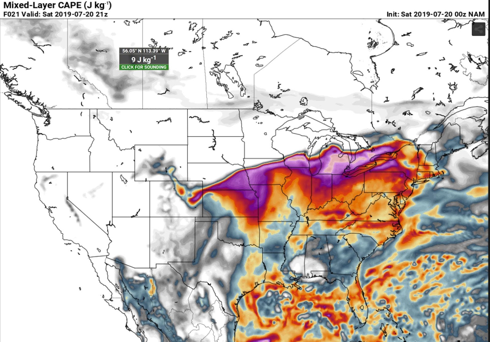
Saturday (today) has a chance to have an EVEN MORE unstable air mass compared to Friday. Temperatures are expected to be a bit hotter, and dew points are expected to climb higher than Friday. Areas across southern Ontario may see temperature/dew point spreads of 92/80F- that is just unbelievable for Ontario. PWAT (precipitable water) values, in some areas, are about 2.5 inches (!!!).

Just absurd amounts of MLCAPE
CAMs, once again, show convection from Michigan dying before reaching Ontario in the early morning. We already have evidence from Friday that this trend is not to be taken as gospel. The morning will tell you whether or not these storms can stay alive with the fuel from the air mass in place. If they do track into Ontario, their timing and placement will be key on where, or if, ouflow boundaries are placed. With the lack of a surefire trigger to ignite storms, such as a cold front, they will need a bit of help to get going. Early morning convection, if it does make it into Ontario, could make Saturday seem quite similar to Friday.

So, not much changes for Saturday from Friday's forecast: the 401/403 corridor could get subjected to more high wind, torrential rain, and frequent lightning anywhere the lake breeze sets up. These volatile air masses make lake breeze boundaries good starting points; especially with a lack of a definitive trigger. Outflow boundaries from preexisting storms (if applicable) may also be factors. I still think early morning storms, whether they're modeled well, or horrifically (like Friday), may play a key role in shaping how Saturday unfolds. Storms could also be going up early again; early afternoon, as opposed to later in the day. There could be multiple rounds as well, especially as you go further southwest.

London area, 18z
I think the best areas, once again, for severe thunderstorm (and slight tornado chance depending on how discrete storms remain and how they interact with surroundings) ends up being in the Grand Bend, London, Windsor triangle area, with another chance at more of the same storms along the 401/403 corridor. Area wise, it doesn't look like much has changed from yesterday, but if morning runs show something different, I'll make sure to cover it.

Stay cool, stay hydrated and stay weather aware tomorrow. For those that loathe this kind of air mass, relief is on the way on Sunday.


12z Update:

Model consensus in the morning has shown quite a bit of change. They've been showing a nasty line of storms heading into Ontario along eastern Lake Huron around 00z instead of having semi-discrete storms that the previous 00z runs had shown, which would have been similar to yesterday. The expectation is that the weak cap will hold with little to no triggers (especially as no storms came through earlier in the day laying down outflow boundaries). If this were to be the case, brutal rain and very strong winds will be the primary threats for as long as the bow echo tracks southeast. This can, and likely will, include the area mentioned in the forecast above, and anywhere from Guelph, Hamilton, Burlington and south. 


Wednesday, June 26, 2019

Friday, June 28th. Severe Weather Threat Across Southern Ontario


First Look: Wednesday June 26, 2019.

Southern Ontario has been relatively quiet in terms of severe weather this year. We've had lots of rain and below seasonal temperatures, but a distinct lack of notable thunderstorms heading into the end of June. That severe weather drought could be looking at its demise coming this Friday.

The classic prerequisite statement for Ontario: there is a lot of uncertainty still to resolve, and that is to be expected several days away. Mesoscale parameters (lake breeze and other surface boundaries; potential ongoing convection pushing east into the province in the morning, amount of cloud clearing and therefore, CAPE available) likely won't be resolved until Friday, so that, and synoptic features (position of the surface low, magnitude of speed/directional shear) will determine what we get on Friday. Patience is a virtue (or so they say).

Depending on the model you look at, this could mean a severe weather outbreak
(the 6/26, 00z NAM), something less intense, but perhaps photogenic (6/26, 00z GFS), or little to nothing at all in terms of severe weather (6/26, 00z SREFs). Energy is the big question as of the 00zs.

In terms of general question marks, the strength and timing of speed/directional shear (higher amounts appear to arrive after storms are already in progress/dying), and the magnitude of CAPE (energy) available, are concerns with this system. It is a situation worth monitoring heading into the Canada Day weekend, as I'm sure plenty of people will be traveling around the province and/or enjoying the weather outdoors (whether sun or storms is good weather to you is relative).


Thursday 00Z Model Run Update


While the discrepancy between models seems to have become more focused (as expected), there are still questions on the timing, and strength, of the storms heading into southern Ontario on Friday. As of now, it looks like two waves of precipitation are likely to occur.

With the vort max (top left panel) nearing southern Ontario in the morning, ongoing convection due to the uplift from that vort max will enter the Lake Huron shoreline area in the late morning/early afternoon. The strength and duration of this precipitation will help shape the rest of the day. If it lingers, and the cloud cover with it prevents diurnal heating and instability to build, the second wave of precipitation likely won't be as strong. If the first wave doesn't last long and cloud cover moves east quickly (allowing for strong heating and instability to build), the second wave, which should form later in the afternoon, may be stronger.


In terms of threat, the first wave looks to be a strong straight line wind, torrential rain, and maybe some small localized hail in areas of greater instability, in the late morning/early afternoon. If instability builds (it looks to be modest- around 1200 J/kg SBCAPE by 18Z), this line may be into severe thresholds. The first wave should stay linear; more of a mesoscale convective system, as opposed to discrete cells, but it'll be come more clear in the morning runs if this isn't the case.

The second wave has more intense potential, but many conditions:

-How much (if at all) will the atmosphere recover after the first wave of storms passes through? Will CAPE rebound?
-Will storms that fire be discrete? Or will they quickly become linear; reducing the tornado risk?
-Will outflow boundaries/lake breeze convergences, a MCV from the west entering the area serve to provide surface backed winds; enhancing tornado potential for any potential discrete cells?
-The constant among nearly all models is that SW Ontario seems to continuously have the highest available energy, so it is the area to watch for any storm formation east of Lake Huron. Having said that, the further south in Ontario you go, the further away from the best speed/directional shear you go; meaning storms become disorganized and messy faster.
-Another constant is the 700 mb wind increase compared to lower levels. With well mixed soundings, some of those winds may get mixed down to the surface for more intense storms.

I'll look again in the morning and provide and update. I will likely be out trying to get some pictures as well.


Friday, April 19, 2019

Forecast Recap: April 17th and 18th Severe Weather Forecast.


If you missed my previous forecast, click here. 
 
How Did The Forecast Do?

For the second consecutive Dixie Alley event, with the results being less of a surprise than the first, the concerns portion of the forecast won out. Tornadoes did form, but were largely QLCS in nature, or on the ends of squall lines. Storms were very messy, in general. Here is the preliminary SPC storm report page. It currently lists 13 tornadoes, but that count may go up over time as damage surveys are finalized. There was lots of CAPE available for the storms to make use of, and they did so, but the established line of storms crossing into Louisiana and eastward held its strength as it pushed east. As a result, isolated tornado chances were reduced, and damaging wind became the primary concern (and it was, as evident by the 250+ damage reports).

How Did My Forecast Area Do?

Any isolated convection quickly congealed and became linear, which prevented supercells from staying discrete and becoming tornado producers, was the theme for the day once again. I picked Jackson, Mississippi as my area of interest. I came to that conclusion thinking isolated, prefrontal cells may form in an environment lending itself to producing tornadoes, but this did not occur. A confirmed tornado did form around the area in the early afternoon. This is evident on the storm relative velocity (2nd panel) and, well, the confirmed warning in pink on the warning panel. There is a very high chance that no one would see this tornado unless you happened to be right beside it. It was very heavily rain wrapped. This was the trend of the day: rain wrapped, embedded tornadoes. Predicting QLCS tornadoes is brutally difficult, if not impossible. You can predict a general area of interest, which happened to be the correct area in my case. Even being in the correct area, I likely would not have seen this tornado. There was not good enough visibility.

A screenshot of the embedded rotation to the west of Jackson, Mississippi as evident on the 2nd panel (Storm Relative Velocity).

Wednesday, April 17, 2019

April 17th and 18th Severe Weather Forecast.

A three day severe weather event is expected to unfold across the southern Plains, Dixie Alley and the Carolinas spanning April 17th to April 19th. I did not have the time to make an extensive separate forecast for April 17th (today), but will include a brief synopsis and forecast for the 18th and may make a separate forecast for the 19th.

Today (the 17th) will feature a severe risk anywhere from southern Texas up to northern Illinois; with the primary risk areas for tornadoes being located in the warm sector ahead of the dry line across most of Oklahoma, northeastern Texas. There's a second conditional tornado concern across eastern Iowa and northern Illinois along the warm front, ahead of the surface low. All areas have concerns: capping concerns to the south, messy VBV wind profiles in Oklahoma, and uncertainty in models as to both severity issues and whether or not storms will fire exist in the northern target.

The area of largest financial concern is that of the Dallas/Fort Worth metro area that may be subjected to a very large hail and damaging winds. It seems as if this area gets an annual threat of large hail, and today will be another day of risk.

If there was ever a sounding for large hail, this would be it. Near Denton, Tx. 


The Forecast

April 18th- LA/MS/AL

A set up that has some reminders of April 13th will occur tomorrow (April 18th) across Dixie Alley. A high amplitude trough will continue to push eastward and will reach Dixie Alley by mid-day. Low and mid level jets (500 mb 700 mb, and 850 mb), with wind speeds upwards of 50 kts+ in the jets, will be located over eastern Louisiana by 21z. The surface low will also be making its way east and should be over northern LA by 18z tomorrow. The Low Level Jet will continue to intensify throughout the day into western Alabama after 00z. Surface speed and directional shear (SSE winds at the surface) will provide a favorable environment for supercells and tornadoes, but with strong low level forcing likely to amalgamate storms that form, especially later in the day, the isolated supercell/tornado risk may be limited in time and based on prefrontal trough supercells and their advance. Additionally, storms may become severe and present the damaging wind, torrential rain and embedded QLCS tornadoes early on (15z), so those living in Louisiana should be on alert early.

A sounding for eastern Mississippi at 21z. Speed and directional shear look pretty good (especially at the low levels), but CAPE (energy) is a concern; at least for the NAM 3k.

Energy for the storms to utilize is still a bit of an unknown at this point, as there's plenty of model disagreement. With mid 70F temps, and dew points in the high 60s, low 70Fs, such a small dew point depression will lend to very low LCLs, but preexisting storms moving east from today (well, as I write this, storms are firing in central Texas) and cloud cover that they bring may put a damper on total energy availability due to a lack of solar heating. This will sort itself out in the morning.

Projected cloud cover for 18z tomorrow suggests that low level cloud (both for GFS/NAM) will be present over the target states.

In general, the further east you go, and the later you wait, the better the Storm Relative Helicity will be as the LLJ picks up, but in doing so, he higher the chance that the storm threat becomes linear. CAPE also becomes a concern the further east you go.


Storm Concerns/Target Area


1) No guarantee of strong instability. As stated before, there's a ton of model disagreement on CAPE, cloud cover and preexisting convection moving into the target area, and these are unlikely to be clarified until the morning. With clearing, diurnal heating and strong low level flow, CAPE levels may lead to very strong storms. Prefrontal cells could become tornado producers.

2) Quick upscale growth of storms. Similar to April 13th, strong forcing at the surface with the cold front pushing east and a strong LLJ may lead to the quick linear convergence of any discrete storms, which would reduce the tornado risk. This isn't going to rule it out completely (Dixie has a habit of producing QLCS tors, like those after dark last week), so it is still a concern.

3) Some VBV in SKEW-Ts may lead to messy storms, or hinder their growth, early before the strong low level shear and SRH begins to increase. More messy HP storms are possible.

4) A bit nit picky, but I'd like to see a bit more veering (more of a westerly upper level wind component) above the 700 mb mark, but if low level shear, especially below the 3km mark, is as intense as forecast, this shouldn't matter as much.


If I had to choose a time/location to target for a chance at tornadoes, I'd pick somewhere near Jackson, Mississippi. I'll be honest, however: I'm not very confident in this target because I'd be hoping for prefrontal cells firing in an environment with building shear and, hopefully, building instability. Anything west of that target area would likely already be linear in nature. The morning will determine the outcome of supercell and tornado formation based on instability. Even if the tornado risk remains minimal, localized flash flood and damaging winds are still a major risk.

Sunday, April 14, 2019

Forecasting Recap: ArkLaTex Severe Weather Event. April 13th, 2019.


Surface Analysis for 18z showing the northward movement of the warm front and the progression of the east moving cold front into east Texas and Louisiana.
 If you haven't read my forecast for this day, you can click here.

How Did The Forecast Do? What Happened Throughout The Day?

As I was over 1,200 miles away from the system, I was arm chair forecasting and observing from home. The strong speed and directional shear, and high dew points went exactly as forecast: very intense. Storm Relative Helicities (both 0-1 km and 0-3 km) exceeded 250 m2/s2, suggesting strong rotation in any storm with a strong updraft. This was a surprise to no one, though; given the synoptic set up. The warm front rose north early in the day (you can check the 18z surface analysis above) and reached extreme north Louisiana by 21z. This increased the size of the warm sector, in tandem with diurnal heating, allowed for instability to build quickly as whatever small amount of CIN (capping) was eroded. Storms, due to the prefrontal trough, an advancing cold front, a completely uncapped warm sector, and extremely low LFCs (requiring little forcing for storms to form) began to erupt early and continued to fire into the afternoon. 

Unfortunately, there were people killed due to the flooding and high winds associated with this widespread event. 5

The day starting off early with a confirmed tornado located near Franklin, Texas in the morning (around 11am CST). Many believed that this would be a sign of things to come. 465

Not many discrete cells as of 21z.
From around 21z on, the majority of discrete storms that formed in eastern Texas and Louisiana quickly became congealed, or linear. As a whole, storm mode became very messy, and it became a largely wind and high precipitation event in Louisiana.

Lack of discrete cells notwithstanding, QLCS (embedded) tornadoes were still a threat among the linear convection. This was the case with at least one confirmed tornado hitting the town of Vicksburg, Mississippi as part of at least one tornado embedded in a QLCS

There was also a later in the night scare, as another embedded-in-a-squall-line tornado was on a collision path with MSU Campus. The good news was no injuries were reported. Nocturnal tornado reports as part of the eastward moving QLCS would continue throughout the night, with Monroe County, MS being hit particularly hard.


Overall, I do wish I had considered the faster eastward track into western Mississippi and Alabama later in the day (I did not think they'd reach that area until well into the night. They arrived in those states faster than I thought). The abundance of messy storms as a result of upscale growth was confirmed. The lack of discrete tornadoes was a possibility that I mentioned in the concerns section of my forecast; largely depending on storm mode and warm sector forcing, but truthfully, I thought the parameters in place would have meant more discrete tornadoes ahead of the strongest forcing. Thankfully, that did not occur.

I also underestimated just now frequent and intense the embedded, nocturnal, tornadoes would be once they tracked into Mississippi.The hodographs had hinted at an environment prone to rotating storms, but I was not expecting the number and intensity of some of the tornado reports.

As a side note, I do plan on making future forecasts more in-depth. I decided to start a blog late last night on a whim, so there's a bit of a learning curve. 

The (Nearly) Final Storm Reports

Here is the preliminary total of storm reports that include tornado, hail, and wind damage reports. Total reports should increase in the coming days as damage surveys are conducted. The night before, and morning of, suggested that tornadic parameters were very high and it was quite likely that several tornadoes - some of which could be violent and long tracked - would occur across the ArkLaTex and western Mississippi. As I write this recap, I'm sure most people closely monitoring this event were expecting a higher confirmed amount of tornadoes on the day, and thankfully, that was not the case. This event ended up being a larger localized flooding threat in Louisiana than a tornado threat.

How Did My Target Area Do?

Isolated convection quickly congealing and becoming linear prevented supercells from staying discrete and becoming strong tornado producers. An example of broad rotation just north of the target area was observed around 2 pm CST. This was not surprising, considering the supercell/tornado parameters discussed in the previous day's forecast, but no tornadoes were produced in the immediate area. To give you an idea of the volatility of the atmosphere, here's a look at a box and whisker plot showing all tornado ingredients at or exceeding strong tornado parameters in the area.

I would not have seen a tornado had I been chasing that day; considering the chosen target area. I can say that I may have pushed back to the north and east to stay ahead of the upscale growth, but there's no way of confirming that I would have been able to cover that much ground in a very messy, very rainy day. The roads may have been subjected to flooding as well. There would have been a chance at great lightning opportunities outside of the main rain cores, so I may have tried my luck there. I don't like these types of grungy, low visibility, fast moving storms, so I likely would have stopped early and gone to watch the NBA playoffs.

Until the next event...

Saturday, April 13, 2019

ArkLaTex Severe Weather/Tornado Forecast. For April 13th, 2019.


The Day Before The Event
A severe weather event, scheduled to unfold later today (it is 1:30 am EST as I type this), certainly has dangerous ramifications associated with a few states across the southern US on Saturday. At the very least, the ArkLaTex region (and likely western Mississippi/Alabama) will be subjected to torrential rain, with the threat of localized flooding, damaging winds, and perhaps several strong, long tracked tornadoes. The SPC and medium/long range models knew of this possibility at least 5 days ahead, and there has been no indication that this system has lost any steam along the way. As of 2:20 am EST, a Moderate risk has been issued for much of the ArkLaTex region and western Mississippi. This may get raised to a High risk tomorrow depending on the evolution of the low's progression and how conditions in the warm sector unfold.

If you live in these states, and neighboring states, be very cautious of the weather today. This includes all areas of the outlook and not just those in the Moderate concern. Create a plan that stresses safety for you and your family: An area to take shelter, or somewhere to drive away from the storm (if living in a building that does not have suitable cover, or a mobile home). Have an idea of what you're going to do if tornadoes become a strong possibility in your region. Storms will be fast moving and intense. You must be ready to act immediately.

The Forecast 

Normally I would go into greater depth, but it's close to 2 am, so I'm going to do a basic rundown. I'll expand further for future events. 

A powerful trough digs its way down nearly into the Gulf of Mexico, with a nearly 100 kt jet streak over eastern Texas as of 21z Saturday (shown below). On the Skew-T (shown below) for Northern Louisiana, you can see both strong speed and directional shear; there isn't an area on the wind field that has less than a 50 kt wind barb until you reach the lower levels of the atmosphere (around 950 mb). You also see veering; especially from the surface winds up to 850 mb. This deep layer shear profile will be very favorable for supercells.

With SRH values exceeding 400 m2/s2 from 0-1 km, and values exceeding 500 m2/s2 from 0-3 km, strong tornadoes are likely on supercells that can remain discrete and prevent being amalgamated by ongoing linear convection, or collisions into other supercells. QLCS tornadoes (supercells that are embedded as part of linear convection) are still a strong possibility here even with linear convection. 

Both the LCL (the base of the cloud formation level) and the LFC (the level at which a saturated parcel of air will continue to rise moist adiabatically) are very low in the sounding, which indicates a low dew point depression and increased chance of tornadogenesis (among other factors). These will be very low in the sky clouds, which presents a visibility risk in terms of seeing the tornado. You may not see it until it is very close as a result.

The 500 mb trough dipping south. Note the jet streak associated with it entering the area with the severe weather outlook.

In terms of energy, the warm sector tomorrow may be the determining key on just how significant this outbreak ends up being:

-If prominent cloud remains in the morning, or pre-frontal storms ignite early, overall energy (CAPE) will not be maximized by diurnal heating. In all honesty, however, this is likely spitting hairs. With dew point temperatures likely to reach the mid 60s and even past 70F in some areas, and models hinting at the warm front eliminating the little cap in place early, there should still be plenty of CAPE for supercell development.

-IMO, with lots of energy, shear, and incredible helicity indices, the largest mitigating factor to tornadogenesis may be the uncapped warm sector. With strong surface forcing at and ahead of the cold front, storms may form "en masse", or as a group, instead of separately. If a mass of storms erupts and combines quickly, the tornado threat will likely be reduced.

The 21z Skew-T for the area ~30 miles SE of Shreveport, LA. 


Storm Chasing Concerns And Target Area

I will not be chasing this event, as I'll be at home over 1,200 miles away, but I'll discuss the concerns that I would have chasing this event if I was there. To round out the blog, I will pick a target area (that I may refine in the morning).

Concerns:

1) Storm motions will be very fast; 50+ kts. This means you will not be able to keep up with, or outrun them; even if your road network was perfect. You must get ahead and try to clear out of the RFD or any other dangerous aspect of the storm that you will be in close proximity to. The Red River cuts through western Louisiana from NW to SE, so if you're west of the river, there are very few crossings to go east. You may end up being trapped. The same goes with the Mississippi River in the east of the state.

2) Northern Louisiana has extremely high tree density, and as a result, limited visibility to see the storms approaching you. Very low LCLs mean you won't see a tall rope tornado, you'll likely see a wall of cloud. The trees will obstruct this view. Not to mention, these trees become projectiles if you're near the tornado or areas with high straight line winds. Here's an example of what I'm talking about.

3) With the potential of storms moving through in the morning, and "training" (supercells moving over the same area repeatedly), localized flooding now becomes a risk. We've already discussed low visibility being an issue in a few different ways above, but now couple that with a shrinking road network (that wasn't prominent to begin with), and your overall level of risk skyrockets. Escape routes become limited, and you won't outrun these fast moving storms.

Target Area

Overall, I'm not a big fan of grungy, non-photogenic, fast moving, "close proximity to the Gulf" storms tend to be, but the area around city of Winnfield would be my target area. Not to mention, the risks are much higher with this system as I covered in the "Concerns" section.

Saturday presents a very real danger. To those in the risk area: best of luck, and be weather ready tomorrow.