Showing posts with label Tornado. Show all posts

Friday, April 19, 2019

Forecast Recap: April 17th and 18th Severe Weather Forecast.


If you missed my previous forecast, click here. 
 
How Did The Forecast Do?

For the second consecutive Dixie Alley event, with the results being less of a surprise than the first, the concerns portion of the forecast won out. Tornadoes did form, but were largely QLCS in nature, or on the ends of squall lines. Storms were very messy, in general. Here is the preliminary SPC storm report page. It currently lists 13 tornadoes, but that count may go up over time as damage surveys are finalized. There was lots of CAPE available for the storms to make use of, and they did so, but the established line of storms crossing into Louisiana and eastward held its strength as it pushed east. As a result, isolated tornado chances were reduced, and damaging wind became the primary concern (and it was, as evident by the 250+ damage reports).

How Did My Forecast Area Do?

Any isolated convection quickly congealed and became linear, which prevented supercells from staying discrete and becoming tornado producers, was the theme for the day once again. I picked Jackson, Mississippi as my area of interest. I came to that conclusion thinking isolated, prefrontal cells may form in an environment lending itself to producing tornadoes, but this did not occur. A confirmed tornado did form around the area in the early afternoon. This is evident on the storm relative velocity (2nd panel) and, well, the confirmed warning in pink on the warning panel. There is a very high chance that no one would see this tornado unless you happened to be right beside it. It was very heavily rain wrapped. This was the trend of the day: rain wrapped, embedded tornadoes. Predicting QLCS tornadoes is brutally difficult, if not impossible. You can predict a general area of interest, which happened to be the correct area in my case. Even being in the correct area, I likely would not have seen this tornado. There was not good enough visibility.

A screenshot of the embedded rotation to the west of Jackson, Mississippi as evident on the 2nd panel (Storm Relative Velocity).

Wednesday, April 17, 2019

April 17th and 18th Severe Weather Forecast.

A three day severe weather event is expected to unfold across the southern Plains, Dixie Alley and the Carolinas spanning April 17th to April 19th. I did not have the time to make an extensive separate forecast for April 17th (today), but will include a brief synopsis and forecast for the 18th and may make a separate forecast for the 19th.

Today (the 17th) will feature a severe risk anywhere from southern Texas up to northern Illinois; with the primary risk areas for tornadoes being located in the warm sector ahead of the dry line across most of Oklahoma, northeastern Texas. There's a second conditional tornado concern across eastern Iowa and northern Illinois along the warm front, ahead of the surface low. All areas have concerns: capping concerns to the south, messy VBV wind profiles in Oklahoma, and uncertainty in models as to both severity issues and whether or not storms will fire exist in the northern target.

The area of largest financial concern is that of the Dallas/Fort Worth metro area that may be subjected to a very large hail and damaging winds. It seems as if this area gets an annual threat of large hail, and today will be another day of risk.

If there was ever a sounding for large hail, this would be it. Near Denton, Tx. 


The Forecast

April 18th- LA/MS/AL

A set up that has some reminders of April 13th will occur tomorrow (April 18th) across Dixie Alley. A high amplitude trough will continue to push eastward and will reach Dixie Alley by mid-day. Low and mid level jets (500 mb 700 mb, and 850 mb), with wind speeds upwards of 50 kts+ in the jets, will be located over eastern Louisiana by 21z. The surface low will also be making its way east and should be over northern LA by 18z tomorrow. The Low Level Jet will continue to intensify throughout the day into western Alabama after 00z. Surface speed and directional shear (SSE winds at the surface) will provide a favorable environment for supercells and tornadoes, but with strong low level forcing likely to amalgamate storms that form, especially later in the day, the isolated supercell/tornado risk may be limited in time and based on prefrontal trough supercells and their advance. Additionally, storms may become severe and present the damaging wind, torrential rain and embedded QLCS tornadoes early on (15z), so those living in Louisiana should be on alert early.

A sounding for eastern Mississippi at 21z. Speed and directional shear look pretty good (especially at the low levels), but CAPE (energy) is a concern; at least for the NAM 3k.

Energy for the storms to utilize is still a bit of an unknown at this point, as there's plenty of model disagreement. With mid 70F temps, and dew points in the high 60s, low 70Fs, such a small dew point depression will lend to very low LCLs, but preexisting storms moving east from today (well, as I write this, storms are firing in central Texas) and cloud cover that they bring may put a damper on total energy availability due to a lack of solar heating. This will sort itself out in the morning.

Projected cloud cover for 18z tomorrow suggests that low level cloud (both for GFS/NAM) will be present over the target states.

In general, the further east you go, and the later you wait, the better the Storm Relative Helicity will be as the LLJ picks up, but in doing so, he higher the chance that the storm threat becomes linear. CAPE also becomes a concern the further east you go.


Storm Concerns/Target Area


1) No guarantee of strong instability. As stated before, there's a ton of model disagreement on CAPE, cloud cover and preexisting convection moving into the target area, and these are unlikely to be clarified until the morning. With clearing, diurnal heating and strong low level flow, CAPE levels may lead to very strong storms. Prefrontal cells could become tornado producers.

2) Quick upscale growth of storms. Similar to April 13th, strong forcing at the surface with the cold front pushing east and a strong LLJ may lead to the quick linear convergence of any discrete storms, which would reduce the tornado risk. This isn't going to rule it out completely (Dixie has a habit of producing QLCS tors, like those after dark last week), so it is still a concern.

3) Some VBV in SKEW-Ts may lead to messy storms, or hinder their growth, early before the strong low level shear and SRH begins to increase. More messy HP storms are possible.

4) A bit nit picky, but I'd like to see a bit more veering (more of a westerly upper level wind component) above the 700 mb mark, but if low level shear, especially below the 3km mark, is as intense as forecast, this shouldn't matter as much.


If I had to choose a time/location to target for a chance at tornadoes, I'd pick somewhere near Jackson, Mississippi. I'll be honest, however: I'm not very confident in this target because I'd be hoping for prefrontal cells firing in an environment with building shear and, hopefully, building instability. Anything west of that target area would likely already be linear in nature. The morning will determine the outcome of supercell and tornado formation based on instability. Even if the tornado risk remains minimal, localized flash flood and damaging winds are still a major risk.

Saturday, April 13, 2019

ArkLaTex Severe Weather/Tornado Forecast. For April 13th, 2019.


The Day Before The Event
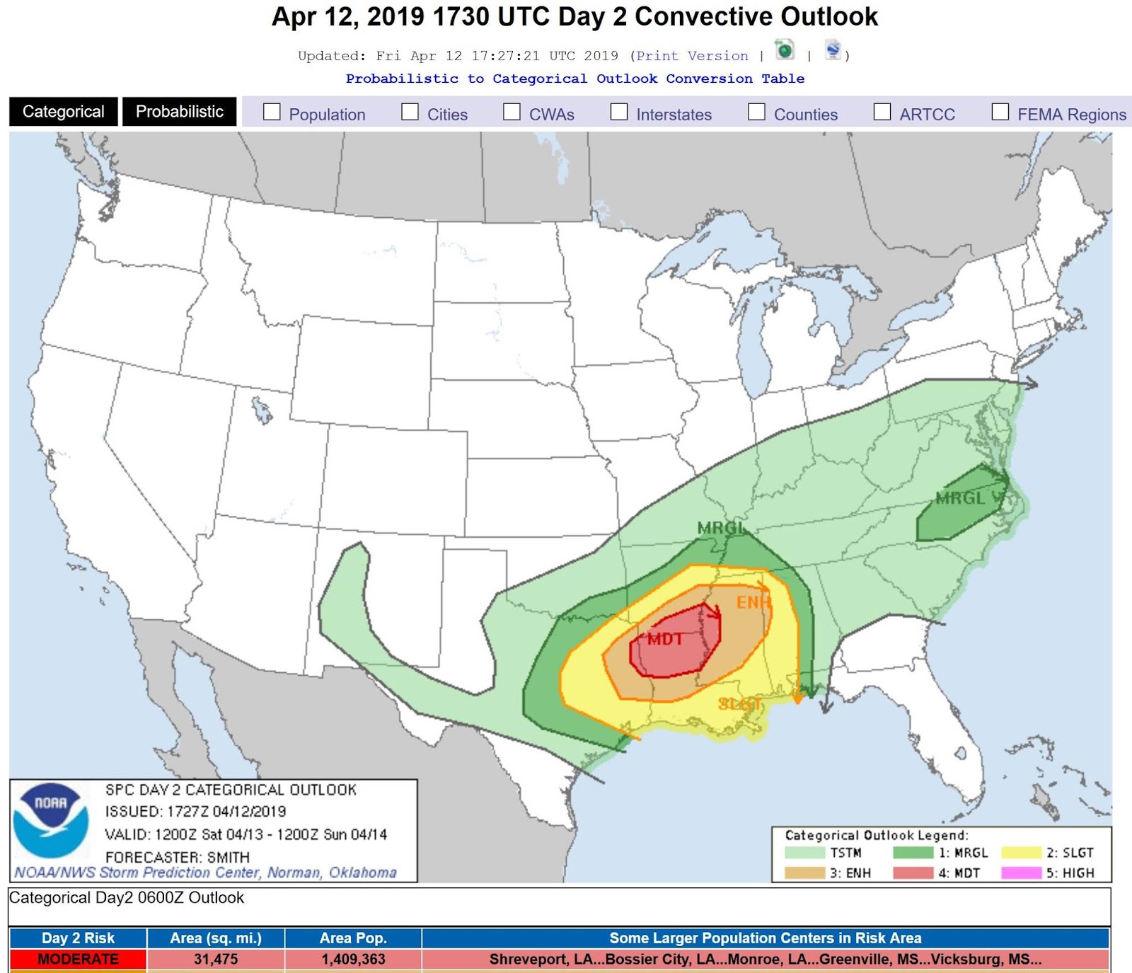
A severe weather event, scheduled to unfold later today (it is 1:30 am EST as I type this), certainly has dangerous ramifications associated with a few states across the southern US on Saturday. At the very least, the ArkLaTex region (and likely western Mississippi/Alabama) will be subjected to torrential rain, with the threat of localized flooding, damaging winds, and perhaps several strong, long tracked tornadoes. The SPC and medium/long range models knew of this possibility at least 5 days ahead, and there has been no indication that this system has lost any steam along the way. As of 2:20 am EST, a Moderate risk has been issued for much of the ArkLaTex region and western Mississippi. This may get raised to a High risk tomorrow depending on the evolution of the low's progression and how conditions in the warm sector unfold.

If you live in these states, and neighboring states, be very cautious of the weather today. This includes all areas of the outlook and not just those in the Moderate concern. Create a plan that stresses safety for you and your family: An area to take shelter, or somewhere to drive away from the storm (if living in a building that does not have suitable cover, or a mobile home). Have an idea of what you're going to do if tornadoes become a strong possibility in your region. Storms will be fast moving and intense. You must be ready to act immediately.

The Forecast 

Normally I would go into greater depth, but it's close to 2 am, so I'm going to do a basic rundown. I'll expand further for future events. 

A powerful trough digs its way down nearly into the Gulf of Mexico, with a nearly 100 kt jet streak over eastern Texas as of 21z Saturday (shown below). On the Skew-T (shown below) for Northern Louisiana, you can see both strong speed and directional shear; there isn't an area on the wind field that has less than a 50 kt wind barb until you reach the lower levels of the atmosphere (around 950 mb). You also see veering; especially from the surface winds up to 850 mb. This deep layer shear profile will be very favorable for supercells.

With SRH values exceeding 400 m2/s2 from 0-1 km, and values exceeding 500 m2/s2 from 0-3 km, strong tornadoes are likely on supercells that can remain discrete and prevent being amalgamated by ongoing linear convection, or collisions into other supercells. QLCS tornadoes (supercells that are embedded as part of linear convection) are still a strong possibility here even with linear convection. 

Both the LCL (the base of the cloud formation level) and the LFC (the level at which a saturated parcel of air will continue to rise moist adiabatically) are very low in the sounding, which indicates a low dew point depression and increased chance of tornadogenesis (among other factors). These will be very low in the sky clouds, which presents a visibility risk in terms of seeing the tornado. You may not see it until it is very close as a result.

The 500 mb trough dipping south. Note the jet streak associated with it entering the area with the severe weather outlook.

In terms of energy, the warm sector tomorrow may be the determining key on just how significant this outbreak ends up being:

-If prominent cloud remains in the morning, or pre-frontal storms ignite early, overall energy (CAPE) will not be maximized by diurnal heating. In all honesty, however, this is likely spitting hairs. With dew point temperatures likely to reach the mid 60s and even past 70F in some areas, and models hinting at the warm front eliminating the little cap in place early, there should still be plenty of CAPE for supercell development.

-IMO, with lots of energy, shear, and incredible helicity indices, the largest mitigating factor to tornadogenesis may be the uncapped warm sector. With strong surface forcing at and ahead of the cold front, storms may form "en masse", or as a group, instead of separately. If a mass of storms erupts and combines quickly, the tornado threat will likely be reduced.

The 21z Skew-T for the area ~30 miles SE of Shreveport, LA. 


Storm Chasing Concerns And Target Area

I will not be chasing this event, as I'll be at home over 1,200 miles away, but I'll discuss the concerns that I would have chasing this event if I was there. To round out the blog, I will pick a target area (that I may refine in the morning).

Concerns:

1) Storm motions will be very fast; 50+ kts. This means you will not be able to keep up with, or outrun them; even if your road network was perfect. You must get ahead and try to clear out of the RFD or any other dangerous aspect of the storm that you will be in close proximity to. The Red River cuts through western Louisiana from NW to SE, so if you're west of the river, there are very few crossings to go east. You may end up being trapped. The same goes with the Mississippi River in the east of the state.

2) Northern Louisiana has extremely high tree density, and as a result, limited visibility to see the storms approaching you. Very low LCLs mean you won't see a tall rope tornado, you'll likely see a wall of cloud. The trees will obstruct this view. Not to mention, these trees become projectiles if you're near the tornado or areas with high straight line winds. Here's an example of what I'm talking about.

3) With the potential of storms moving through in the morning, and "training" (supercells moving over the same area repeatedly), localized flooding now becomes a risk. We've already discussed low visibility being an issue in a few different ways above, but now couple that with a shrinking road network (that wasn't prominent to begin with), and your overall level of risk skyrockets. Escape routes become limited, and you won't outrun these fast moving storms.

Target Area

Overall, I'm not a big fan of grungy, non-photogenic, fast moving, "close proximity to the Gulf" storms tend to be, but the area around city of Winnfield would be my target area. Not to mention, the risks are much higher with this system as I covered in the "Concerns" section.

Saturday presents a very real danger. To those in the risk area: best of luck, and be weather ready tomorrow.